» posted on Tuesday, July 12th, 2022 by Linda Lou Burton
The Hot Spot
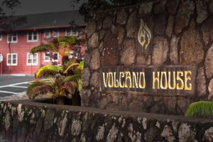 Originally Published July 15, 2020 by Linda Lou Burton posting about Hawaii Volcanoes from Little Rock, Arkansas – Some folks go to Hawaii to sit on the beach and drink Mai Tai’s, peering at the ocean over a slab of pineapple on the rim of their glass. Peering over the rim of a volcano is what I’m interested in, and it is the main attraction at Volcano House on the big island of Hawaii. The “only volcano hotel in Hawaii,” at 1 Crater Rim Drive in Hawaii Volcanoes National Park, Volcano House is a historic retreat right by the rim. “Breathtaking” is the word as you gaze over the Kilauea
 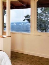 caldera from your room. From your room! You are on the edge of an active volcano and a UNESCO Heritage Site, 4,000 feet above sea level.
I wake up this morning in my king-size bed (on my “vacation that would have been if not for a world crisis”) and watch as wisps of smoke curl over the barren landscape. An ever-evolving landscape, shaped by volcanic activity, always a ticking clock.
 Volcanoes are the “fast-forward” of geological construction. Winds and waters eroded out the Grand Canyon over eons, ice-age glaciers took a while to scrape out the Great Lakes. But volcanoes do their bit in a hurry. Blam! Ash goes flying, hot lava flows, and anything in the pathway is toast. Result: new land is formed, old land is reshaped.
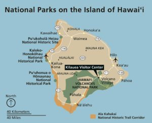
Do you know about The Hot Spot? That’s the baby-maker of the Hawaiian island chain, and it continues to build islands. The tectonic plate beneath much of the Pacific Ocean keeps moving northwest, but the “hot spot” remains stationary, creating new volcanoes. Currently active volcanoes are on the southern half of Hawaii island; the newest, Lōʻihi Seamount, is located south of the coast.
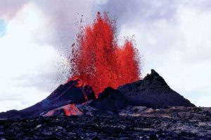
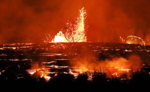 Haleakalā, on Maui, erupted sometime in the 18th century, possibly earlier. Kīlauea exploded in 1790, the deadliest eruption known to have occurred in what is now the United States. It erupted again in May 2018, opening 22 fissure vents on its East Rift Zone. The destruction, coupled with lava flows and sulfur dioxide fumes, necessitated the evacuation of more than 2,000 people.
It’s quiet today. Sensors and video cams keep track of every gurgle and tremor, you betcha. Mauna Loa, about 20 miles northwest of Kilauea and the largest active volcano on earth, last erupted in 1984. For a virtual visit, check out a few live cams, courtesy of the USGS Hawaiian Volcano Observatory.
https://www.nps.gov/havo/learn/photosmultimedia/webcams.htm
- Kīlauea Caldera from HVO Observation Tower is a live panorama of Kīlauea Caldera.
- Halemaʻumaʻu, water lake, gives a live panorama from the west rim of the new summit collapse features; Thermal image of Halemaʻumaʻu and water lake is a live thermal image.
- Mokuʻāweoweo Caldera from the Northwest Rim, positioned on the rim of Mauna Loa volcano, is a temporary research camera. If you look carefully around early morning or late evening, you may see a few thermal areas emitting steam.
- Mokuʻāweoweo Caldera Thermal is a temporary thermal camera there; the temperature scale is in degrees Celsius up to a maximum of 500 degrees (932 degrees Fahrenheit).
Volcanoes are hot!
 But there are also plenty of cool things within the 4,028 square miles that make up the Big Island of Hawaii. Trails through rainforest lead to hide-away waterfalls; black-sand beaches are the place to catch a sea turtle napping. Devastation Trail winds through exotic flora and fauna and now-cooled lava flows. Imagine yourself walking through a 35-foot-high lava tube! The highest point on the island is Mauna Kea. At 13,796 fee it is (just barely) 125 feet higher than Mauna Loa. The lowest point in Hawaii is at water’s edge – the Pacific Ocean.
Where you can sit on the beach and drink Mai Tai’s, with a nibble of pineapple, if you please.
Hawaii Volcanoes National Park https://www.nps.gov/havo/index.htm
Volcano House https://www.hawaiivolcanohouse.com/